常用流域地貌形态测量参数汇总与计算方法.docx
《常用流域地貌形态测量参数汇总与计算方法.docx》由会员分享,可在线阅读,更多相关《常用流域地貌形态测量参数汇总与计算方法.docx(41页珍藏版)》请在冰点文库上搜索。
常用流域地貌形态测量参数汇总与计算方法
常用流域地貌形态测量参数汇总与计算方法
(版本2,更新时间2021.1.6)
赵岩
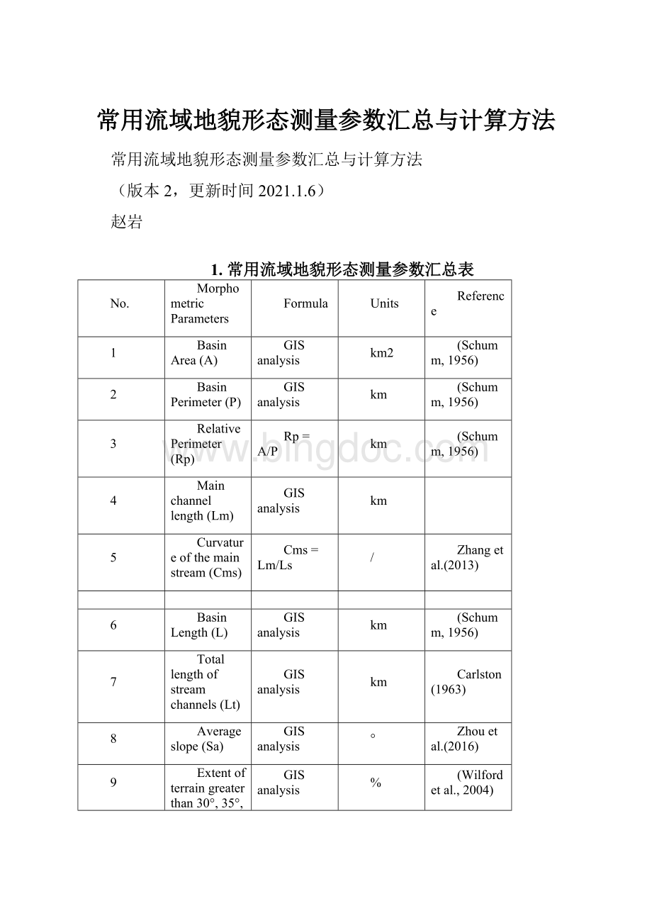
1.常用流域地貌形态测量参数汇总表
No.
MorphometricParameters
Formula
Units
Reference
1
BasinArea(A)
GISanalysis
km2
(Schumm,1956)
2
BasinPerimeter(P)
GISanalysis
km
(Schumm,1956)
3
RelativePerimeter(Rp)
Rp=A/P
km
(Schumm,1956)
4
Mainchannellength(Lm)
GISanalysis
km
5
Curvatureofthemainstream(Cms)
Cms=Lm/Ls
/
Zhangetal.(2013)
6
BasinLength(L)
GISanalysis
km
(Schumm,1956)
7
Totallengthofstreamchannels(Lt)
GISanalysis
km
Carlston(1963)
8
Averageslope(Sa)
GISanalysis
°
Zhouetal.(2016)
9
Extentofterraingreaterthan30°,35°,or40°(S30,S35,S40)
GISanalysis
%
(Wilfordetal.,2004)
10
Extentofterrainbetween30°and40°(S30-40)
GISanalysis
%
(Wilfordetal.,2004)
11
Averageaspect(Aa)
GISanalysis
°
12
Basinrelief(H)
H=Hmax-Hmin
km
Strahler(1952)
13
ReliefRatio(Rr)
Rr=H/L
/
(Schumm,1956)
14
RelativeReliefRatio(Rrr)
Rhp=H*100/P
/
(Melton,1957a)
StreamOrder
HierarchicalRank
/
Strahler(1952)
Streamnumber(Nu)
Nu=N1+N2+……+Nn
Horton(1945)
Bifurcationratio(Br)
Br=Nn/Nn+1
/
Strahler(1964)
Streamlengthratio(Lr)
Lr=Ln/(Ln-1)
Strahler(1964)
15
DrainageDensity(Dd)
Dd=Lt/A
/
Horton(1932)
16
StreamFrequency(Fs)
Fs=Nl/A
1/km2
Horton(1932)
17
DrainageIntensity(Di)
Di=Fs/Dd
(Faniran,1968)
18
CircularityRation(Cr)
Cr=4πA/P2
/
Strahler(1964)
19
Formfactor(Ff)
Ff=A/L
km
Horton(1932)
ShapeFactorRatio(Sf)
Sf=Lb2/A
Horton(1945)
20
ElongationRatio(Er)
Er=2
/
(Schumm,1956)
21
Compactnessindex(Ci)
Ci=P/2
/
Zavoianu(1985)
22
HypsometricIntegral(HI)
HI=(Hmean−Hmin)/(Hmax−Hmin)
/
Pike&Wilson(1971)
23
Meltonratio(Mr)
Mr=H/
/
Melton(1957)
24
纵剖面形态指数(N)
h=H(l/L)N
И.B.Иванов(1955)
25
Planecurvature(Cpl);
GISanalysis
/
26
Profilecurvature(Cpr)
GISanalysis
/
27
Roughness(R)
GDALanalysis
/
Wilsonetal.(2007)
28
RoughnessIndex(Ri)
Ri=A/Ap
/
Kamphorstetal.(2000)
29
Ruggednessnumber(Rn)
Rn=H*Dd
/
Strahler(1952)
30
TerrainRuggednessnumber(TRI)
GDALanalysis
/
Wilsonetal.(2007)
31
TopographicPositionIndex(TPI)
GDALanalysis
/
Wilsonetal.(2007)
32
TopographicWetnessIndex(TWI)
GISanalysis
/
33
SlopeLengthIndex(SLI)
GISanalysis
/
34
SedimentConnectivityIndex(SCI)
GISanalysis
/
Borsellietal.(2008)
35
Fanmeangradient(FMG)
°
36
Fitnessratio(Rf)
Rf=Lm/P
/
(Melton,1957a)
37
Infiltrationnumber(In)
In=Dd*Fs
1/km2
(ParetaandPareta,2012)
2.常用流域地貌形态测量参数详细介绍
(1)面积(Area,A)
流域面积(basinarea,A)是地形上划定的流域面积(Murpheyetal.,1977),一个更大的有效流域面积可以收集更多的降雨(ChangandChao,2006)。
也一定程度反映泥石流物源条件。
通过GIS软件的几何计算(calculategeometry)功能获得。
Basinarea(A)istheareaofthewatersheddefinedtopographically(Murpheyetal.,1977).Alargereffectivewatershedareacancollectmorerainfall(ChangandChao,2006).
单位(unit):
km2。
(2)周长(Perimeter,P)
流域周长(basinperimeter,P)是包围一个流域集水区的地图线的长度。
通过GIS软件的几何计算(calculategeometry)功能获得。
Baisnperimeter(P)isthelengthofamaplinethatenclosesthebasinareaofadrainagebasin.
单位(unit):
km。
(3)相对周长(RelativePerimeter,Rp)
相对周长(RelativePerimeter,Rp)(Schumm,1956)。
Rp=A/P
单位:
km
(4)主沟长度(Mainchannellength,Lm)
主沟道长度(Mainchannellength,Lm)即流域内最长河道的长度,可以反映集水区主沟物质补给长度。
通过GIS软件的几何计算(calculategeometry)功能获得。
Mainchannellength(Lm)isthelongestflowpathinthebasin.
单位:
km。
(5)主沟曲率(Curvatureofthemainstream,Cms)
主沟曲率(Curvatureofthemainstream,Cms)是主流的曲线长度(Lm)与其直线长度(Ls)的比值(Zhangetal.,2013)。
反映了泥石流的泄流能力。
实地调查表明,直道汇流区往往保留有限的松散物质,不易发生泥石流(Lietal.,2017)。
Thecurvatureofthemainstream(Cms)istheratioofthemainstream’curvelengthtoitsstraightlength(Zhangetal.,2013).Itreflectsthedischargecapacityofdebrisflows.Fieldsurveysindicatethatacatchmentwithanstraightchanneloftenretainslimitedloosematerials,whichisnotpronetothedebrisflowoccurrence(Lietal.,2017).
Cms=Lm/Ls
单位:
km/km。
计算方法:
①使用FeatureVerticesToPoints工具根据主沟的线文件生成起、止点;
②使用Append工具将“End”图层追加到“Start”图层;
③使用PointToLine工具将点转换为线,注意LineField选择ORIG_FID;
④计算直线长度
⑤主沟曲率为主沟长度除以直线长度。
(6)流域长度(Basinlength,L)
流域长度被估计为与主流域线平行的流域的最长距离(Schumm,1956)。
在本研究中,流域长度(Basinlength,L)是从集水区口到流域边界最远处点的直线长度(Ilinca,2021)。
L反映了泥石流可以聚集在一起的沉积物,以及可以沿着其路径顺流而下的沉积物(ChangandChao,2006)。
Basinlengthisestimatedasthelongestdimensionofthebasinparalleltotheprincipaldrainageline(Schumm,1956).Inthisstudy,basinlength(L)isthelengthinstraightlinefrombasinmouth(outlet)tothefarthestpointondivide(Ilinca,2021).Lreflectsthedepositsthedebrisflowcangathertogetherandcanbecarrieddownthestreamalongitspath(ChangandChao,2006).
单位:
km。
(7)沟道总长度(Totallengthofstreamchannels,Lt)
流域内河道的总长度(Totallengthofstreamchannels,Lt)
Thetotallengthofstreamchannelsinthebasin(Carlston,1963;PattonandBaker,1976).
单位:
km。
计算方法:
①使用Identify工具标识线数据。
②打开标识后的线文件,增加字段“长度”,并使用这个字段计算线的长度。
③右击“PROVINCE_”字段,选择summarize工具。
汇总统计中选择“长度”字段的“总和”属性。
确定,得到统计结果表数据。
④将得到的表join到集水区面数据即可。
(8)平均坡度(Averageslope,Sa)
平均坡度(averageslope,Sa),它可以反映集水区的整体坡度情况;利用ArcGIS中的空间分析功能获得流域的,影响物质补给类型与体积。
影响坡面径流、汇流快慢。
通过GIS软件的区域统计(zonalstatistic)功能计算获得。
Averageslope(Sa)istheaveragevalueoftheslopewithintheboundaryofeachbasin,whichcanreflecttheoverallslopeofthebasinandslopestability(Zhouetal.,2016).SawasobtainedusingtheSpatialAnalystinArcGIS.
单位:
度(°)。
(9)坡度大于30°、35°和40°的流域面积百分比(Extentofterraingreaterthan30°,35°,or40°,S30,S35,S40)
Thepercentofwatershedareathathasslopesgreaterthan30°,35°,or40°(Wilfordetal.,2004)。
计算方法:
①使用reclassify工具将坡度重分类。
分别将大于30°、35°和40°坡度的栅格提出来赋值为1。
②使用zonalstatisticsastalbe工具统计每个集水区坡度大于30°、35°和40°栅格个数。
③将生成的表格join到集水区文件中。
④分别计算集水区大于30°、35°和40°的面积百分比例。
(10)坡度在30°到40°之间的流域面积百分比(Extentofterrainbetween30°and40°,S30-40)
Thepercentofwatershedareathathasslopesbetween30°and40°(Wilfordetal.,2004)。
(11)平均坡向(Averageaspect,Aa)
影响冰雪积累、消融和降雨量的大小。
(12)高差(Relief,H)
流域高差(Basinrelief,H)是流域内最高点和最低点之间的高程差,它为流域斜坡的地貌和水文特征,特别是侵蚀特性提供了重要的定量评估(PattonandBaker,1976)。
因此,陡坡因子对径流风险和早期水文峰值有重要影响(Wilfordetal.,2004)。
流域高差(H)、平均高程(Hmean)、最大高程(Hmax)和最小高程Hmin通过GIS软件的区域统计(zonalstatistics)功能计算获得。
Basinrelief(H)istheelevationdifferencebetweenthehighestandlowestpointsinawatershed(Patton,1988),whichprovidesasignificantquantitativeassessmentofgeomorphologicalandhydrologicalcharacteristicsprevailingintheslopesofthedrainagebasin,especiallyerosionalproperties(PattonandBaker,1976).Hence,thesteepnessslopefactorcontributestotheriskofrunoffandearlyhydrologicalpeak(Wilfordetal.,2004).
H=Hmax-Hmin
单位:
km。
(13)比降(Reliefratio,Rr)
流域比降(Reliefratio,Rr)为流域高差(H)与流域长度(L)的比值(Schumm,1954)。
Rr是监测流域整个坡面过程及水流动力强度最重要的地形指标之一(AlqahtaniandQaddah,2019;Patton,1988)。
较高的Rr值表明在陡坡上具有早-强的水流能力,特别是强的侵蚀产沙能力(BhattandAhmed,2014)。
集水区起伏度和起伏比较大的集水区能够提供足够的能量用于泥石流的启动和输送(Zhouetal.,2016)。
Reliefratio(Rr)isthebasinreliefdividedbybasinlength(Schumm,1954).Rrisoneofthemostimportanttopographicindicatorsformonitoringtheentireslopeprocessesofthewatershedalongwithflowdynamicintensity(AlqahtaniandQaddah,2019;Patton,1988).HighRrvaluesindicateanearly-intensityflowcapabilitywithacceleratedmorpho-dynamicprocessesonsteepslopes,especiallyintensityerosionandsedimentyield(BhattandAhmed,2014).BasinswithlargerHandRrcanaffordenoughenergyfordebrisflowinitiationandtransportation(Zhouetal.,2016).
Rr=H/L
单位:
km/km。
(14)相对比降(Relativereliefratio,Rrr)
低的地形起伏率意味着地形平缓,高的地形起伏率意味着点的陡坡(Melton,1957a)。
Lowreliefratioimpliesgentletopographyandhigherreliefratiopoint’ssteepslope(Melton,1957a).
Rrr=(H*100)/P
单位:
km/km。
(15)河网密度(Drainagedensity,Dd)
河网密度(Drainagedensity,Dd)(或沟壑密度)为集水区水系总长度与流域面积的比值(Horton,1945),它是构造因素、地貌因素、气候因素和生物因素最终空间结果的有效定量表达。
换句话说,Dd分别对气候、渗透性、表面材料阻力、植被密度、地形、景观剖面图和径流等指标高度敏感。
Dd评估排水网络渠道(drainagenetworkchannels)的紧密程度或汇流情况。
确定在流量模式的背景下的渠道网络系统的效率,从而确定降雨和流量之间的时间,从而达到径流曲线的峰值(AlqahtaniandQaddah,2019)。
Dd值越高,反映了相对较高的溪流密度,较高的径流量,溪流响应较快,因此入渗率较低,而Dd越低,则径流越小,入渗越高(Prasadetal.,2008)。
Drainagedensity(Dd)isthetotallengthofstreamchannelsdividedbywatershedarea,whichreflcetsthecharacterizationofthedegreeofdrainagedevelopment(Horton,1932).TheDdvarieswiththerainfall,relief,infiltrationcapacityofthesoil,andinitialanti-erosionabilityoftheterrain.Therefore,basinswithahigherDdusuallyhaveamorefragmentedsurfaceandworsewaterimpermeability(Melton,1957a;Strahler,1957).
Dd=Lt/A
Ltisthetotallengthofthestreamchannels,Aisthebasinarea.
单位:
km/km2。
(16)河流频率(Streamfrequency,Fs)
河流频率(Streamfrequency,Fs)是一个流域单位面积上的总河道数。
河流频率受到岩石结构、高起伏特征、陡坡、降雨模式、渗透性、地下材料硬度、植被稀疏和流量密度值的影响(Carlston,1963)。
河流频率与河流密度呈正相关。
河流频率值高的盆地,冲积物含量高,渗滤量大,预测地下水潜力大,洪水灾害潜力大(Horton,1932)。
它和河网密度参数成正相关关系,所以做因子分析时只选取河网密度。
Streamfrequency(Fs) isthenumberoftotalchannelsperunitareaofabasin(Bathrellosetal.,2016).Streamfrequencyisunquestionablyaffectedbyrockstructure,highrelieffeatures,steepslopes,patternofrainfall,permeability,thehardnessofsubsurfacematerials,sparsevegetation,anddischargedensityvalues(Carlston,1963). Therefore,basinsthathavehighvaluesofstreamfrequencyresultinginfloodhazardpotentialwithhighalluvialcontent,morepercolation,andtherefore,moregroundwaterpotentialispredicted(Horton,1932).
Fs=Nl/A
Nlisthenumberoftotalchannelsinabasin,Aisthebasinarea.
单位:
1/km2。
(17)排水强度(DrainageIntensity,Di)
(Faniran,1968)提出了排水强度,即水流频率与排水密度之比,排水密度与排水强度呈负相关。
较高的排水密度表明排水强度较低,较低的排水密度表明排水强度较高。
低
 升级会员
升级会员 